
West Deptford Postal Coverage
Six postal areas appear in the working West Deptford geography: 08051, 08063, 08066, 08086, 08093, and 08096. They are service-area research leads, not a claim that each is fully inside the township. The research did not locate a county-published complete ZIP-to-neighborhood chart or a prefilled USPS result that verifies every address. Use the USPS address lookup for the final address-level check.
| ZIP | Areas Covered | Post Office | Notes |
|---|---|---|---|
| 08051 | West Deptford and Mantua-area service region in the working list | Verify through USPS lookup | Accepted city and township coverage were not verified in a prefilled official result. |
| 08063 | National Park postal geography and nearby Gloucester County service area | National Park Post Office, 512 Hessian Ave. | Do not infer that all 08063 addresses are inside West Deptford. |
| 08066 | Paulsboro and West Deptford-area postal geography | Verify each address through USPS | Official county and state lists show West Deptford addresses using this ZIP. |
| 08086 | Thorofare and central West Deptford postal identity | Thorofare Post Office | Township and county offices use this ZIP. |
| 08093 | Westville-area postal geography | Westville Post Office is a nearby alternate | A West Deptford legal parcel must be verified, not assumed. |
| 08096 | Woodbury and West Deptford-area postal geography | Woodbury Post Office is nearby | Postal city can be Woodbury while the legal municipality is West Deptford. |
This West Deptford ZIP code directory is deliberately cautious about areas within each row. ZIPs are delivery geography, not township lines. A road, parcel, or municipal boundary can cross them, and no official local source supported inventing neighborhood names for the table.
West Deptford Postal Anchor
08086 is the clearest central postal anchor in the available material. Gloucester County's municipal directory gives the township address as 400 Crown Point Road, Thorofare, NJ 08086. The official USPS location record identifies the Thorofare Post Office at 300 Crown Point Road Unit A, West Deptford, NJ 08086-9998. That makes 08086 useful context, but it does not turn a postal label into a legal boundary.
The official Thorofare Post Office listing documents the 08086 postal context.
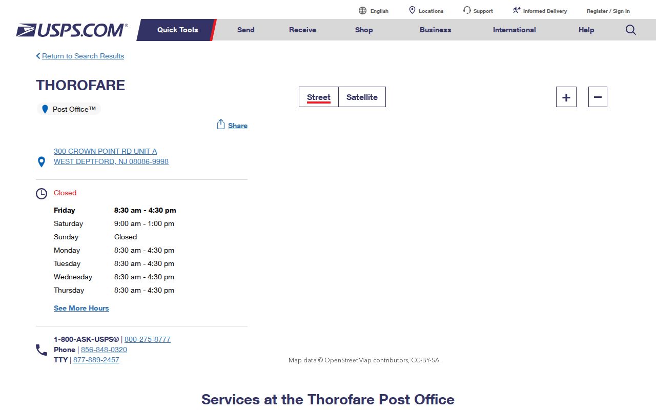
For a mailed item, USPS standardization is the final check. For a property or municipal question, confirm the jurisdiction through the township, county assessment record, GIS parcel, or deed description. A postal result does not confirm that a person or company is at the address.
West Deptford USPS ZIP Modes
USPS offers three separate lookup modes. ZIP Code by Address works from the street address with city and state, or a street plus ZIP. ZIP Code by City and State returns the complete list for a postal city. Cities by ZIP returns accepted city names for the ZIP entered. The distinctions are useful when records use Thorofare, West Deptford, Woodbury, or another postal label.
| USPS field or mode | Type | Required | Use |
|---|---|---|---|
| Street address | Address text | Yes for address lookup | Pairs with city and state, or with a ZIP, to standardize one delivery address. |
| City and state | Place fields | Yes for city and state lookup | Returns postal results for a postal city. |
| ZIP Code by City and State | Search mode | Mode-specific | Finds the ZIP list connected to that postal place. |
| Cities by ZIP Code | Search mode | ZIP required | Shows accepted city names for the entered ZIP. |
USPS warns that standardized formatting can differ from an entered address and should be used for mailing. Save the standardized output with the original source spelling when working with historic material, because an old directory may use a different community name.
West Deptford ZIP Record Searches
A ZIP code directory does not provide a public list of residents. Use the ZIP as a geography check, then follow the public record keyed to the question. The assessment service, GIS, voter portal, and land index do not provide the same type of search. In particular, the voter portal is person and status oriented, not a ZIP-wide resident roll, and the Clerk's land index is organized around parties, documents, and legal descriptions.
- Run the full mailing address through USPS and retain its standardized result.
- Use the county assessment service with the municipality, owner, address, or block and lot when available. Its ZIP-filter behavior was not exposed during research.
- Open the county GIS map, identify the parcel, and record the block and lot before treating a postal label as location evidence.
- Use the voter portal only for its authorized individual-status route. For a lawful election-record request, write to the county office with the municipality, district if known, date range, requested fields, delivery format, and purpose.
- Use the County Clerk land portal to check deeds or maps by name, date, document, volume, or legal-description clues.
Once a ZIP is narrowed to a particular road, the West Deptford street directory explains the address-by-address record route. Do not substitute a ZIP boundary for the parcel boundary.
West Deptford ZIP Filter Gap
The county-linked assessment-records service is countywide, but its JavaScript form did not expose a ZIP filter or its result behavior in the research inspection. The documented fields are municipality, owner, property or situs location, mailing address, block, lot, assessment year, assessments, tax class, exemption or deduction indicators, and tax-map or legal-description references. Treat any live ZIP control as something to verify on screen, not as a promised search method.
| Assessment field | Type | ZIP-search status | Why it matters |
|---|---|---|---|
| Owner name | Text or result | Exact control not exposed | Can provide a public ownership clue with spelling variants. |
| Situs location | Address text | Exact control not exposed | The parcel's physical location, distinct from mailing address. |
| Mailing address | Result field | Not a ZIP filter | Correspondence address that may differ from the parcel. |
| Block and lot | Parcel identifier | Exact control not exposed | Stable bridge to GIS, deeds, tax maps, and legal descriptions. |
| Municipality | Dropdown or result | Exact control not exposed | Select West Deptford within the countywide service when offered. |
The County Assessor is the offline fallback. Its office is at 1200 N. Delsea Drive, Clayton Complex, Building A, Clayton, NJ 08312, phone 856-307-6445. The county says change-of-address or ownership material can be returned by mail, fax, email listed on the form, or in person with supporting documents.
West Deptford ZIP Boundaries
The legal municipal address is not always the USPS preferred city line. West Deptford contains the unincorporated community of Thorofare, and public records can use West Deptford, Thorofare, Woodbury-area, or other postal labels. The township and county GIS establish jurisdiction; USPS establishes how an individual address is standardized for delivery. This mismatch explains why a city-name-only search can miss a historical or current record.
- ZIP Code
- A postal delivery area, not a municipal boundary or a resident list.
- ZIP+4
- An added four-digit delivery detail used after the five-digit ZIP for more precise mail sorting.
- PO-box ZIP
- A postal ZIP assigned to box delivery rather than a general street-delivery area.
- Unique ZIP
- A ZIP assigned to one large organization or recipient; none was verified for West Deptford in this research.
- Carrier route
- A postal delivery grouping that can cross local labels and does not establish a legal property boundary.
Note: A standardized ZIP result confirms delivery geography only, not a person's presence, a household relationship, or a municipal boundary.
West Deptford Postal Labels
The changing postal labels are a local search quirk. County and municipal material uses the Township's Crown Point Road address with Thorofare and 08086, while other official local addresses use 08066 or 08096. A directory, deed, election report, or library listing may preserve the postal community that was appropriate to its date rather than the current searcher's preferred municipality name.
Keep every address form in research notes. Search the name, street, postal label, and municipality separately if a result seems absent. For historic addresses, maps, deeds, and adjacent-owner references often do more work than forcing an older source into a modern postal area.
West Deptford Parcel and ZIP Records
Block and lot, a subdivision name, a deed book and page, or a legal description are more stable than a postal city label. The Gloucester County ArcGIS hub is the map-first bridge: search or pan to an address, click the parcel polygon, and compare its identifier with the assessment record. The landing material did not expose a complete popup-field list or exact layer controls, so confirm the live map display.
For deeds, maps, and instruments, the Gloucester County land-record portal supports Recorded Land and name, recorder-date, document, volume, trade-name, UCC, and maps modes. Maps and plats are indexed from 1836. When a ZIP and township label differ, the parcel and legal description are the better tie-breakers.
West Deptford ZIP Office Split
West Deptford's record geography is split across several offices. Elections are administered at 550 Grove Road in West Deptford, while county assessment work is centralized in Clayton, land records are in Woodbury, and GIS support is at the county Planning Division. Postal geography is only one layer in that arrangement. It does not identify which office holds the record needed.
| Question | Best documented route | ZIP limitation |
|---|---|---|
| Postal form of one address | USPS lookup or Thorofare Post Office | Does not establish township jurisdiction or a person at the address. |
| Parcel and assessment context | County assessment service and GIS | Use municipality, situs, block, and lot rather than a ZIP alone. |
| Election or municipal record | County Elections office or Township Clerk | Election districts and municipal records do not follow ZIP boundaries. |
If a local addressing or readdressing question cannot be resolved by USPS and the parcel map, contact the county GIS and Planning Division at 1200 N. Delsea Drive, 856-307-6650, then the Township Clerk or construction and zoning office. No West Deptford-specific E911 addressing office, renumbering project, or numbering grid was verified. A focused request for local records follows New Jersey's Open Public Records Act, N.J.S.A. 47:1A-1 et seq..